Automatic Generation of HD Maps from Lidar and Aerial Image Data

To reach SAE automation levels 4 and 5 it is important for automated vehicles to plan far ahead into the future, even beyond the perception horizon of their sensors. One possible solution that could solve this issue is the usage of HD maps. When the vehicle is successfully localized in the HD map using its sensors, the map can be used to extend the environmental model. Usually, these maps contain information regarding the road topology, traffic and regulatory elements, and static objects. Typically, these maps are generated by human annotators labeling the mentioned information based on recorded measurement data collected by particular probe vehicles and aerial images. Since this is a time consuming and therefore expensive procedure, we investigated how existing AI-based approaches could be used and adapted for this purpose.
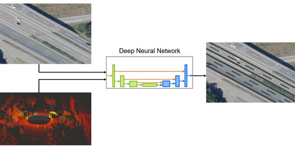
Out of the previously mentioned features road topology information is especially relevant for highway situations. To use the automatically generated maps efficiently, it is convenient to frame them in a standard format. Therefore, we have chosen the Lanelet2 map format. However, we only generate the physical layer where lane markings are defined by means of geo-referenced polylines and their properties. The input data which are lidar point clouds and orthophotos are processed by a convolutional neural network (CNN) to generate these maps automatically. Due to the custom problem definition and specific network output (polylines), the network architecture and the training scheme differ heavily from standard configurations, like object detection or segmentation. Compared to the baseline model our proposed approach suggests improvements and extensions regarding the trainability, the expected possible prediction accuracy, and the output format in the Lanelet2 standard. The generated polylines representing the course, splits, and merges of lane markings can be further refined by a postprocessing step. The lane marking type is determined additionally. Further extensions such as the inclusion of the lane marking color is easily possible due to the modular structure. In addition to the developed CNN-based model and the training procedure, efficient tools for data preparation and preprocessing have been developed within the project. Using them HD maps can be generated manually fast and efficiently as well.

